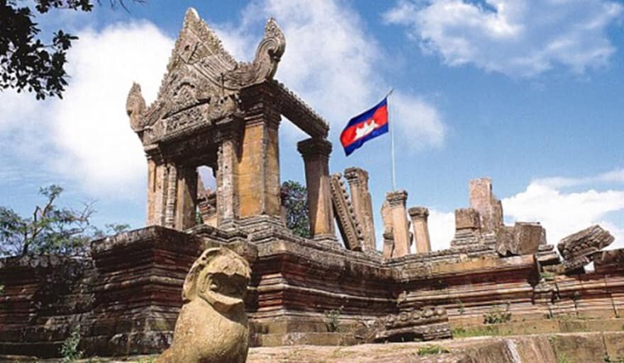
Phnom Penh: 15 June 2020 marks the 58th anniversary (15 June 1962 – 15 June 2020) of the International Court of Justice (ICJ) in The Hague, the Netherlands, deciding on a case between Cambodia and Thailand on the ownership of the Temple of Preah Vihear. The ICJ has ruled in Cambodia’s favor.
In 1904, Siam and the French colonial authorities ruling Cambodia formed a joint commission to demarcate their mutual border to largely follow the watershed line of the Dângrêk mountain range, which placed nearly all of Preah Vihear temple on Thailand’s side. In 1907, after survey work, French officers drew up a map to show the border’s location. However, the resulting topographic map, which was sent to Siamese authorities and used in the 1962 (International Court of Justice (ICJ) ruling, showed the line deviating slightly from the watershed without explanation in the Preah Vihear area, placing all of the temple on the Cambodian side.
Following the withdrawal of French troops from Cambodia in 1954, Thai forces occupied the temple to enforce their claim. Cambodia protested and in 1959 asked the ICJ to rule that the temple and the surrounding land lay in Cambodian territory. The case became a volatile political issue in both countries. Diplomatic relations were severed, and threats of force were voiced by both governments.
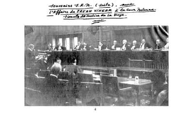
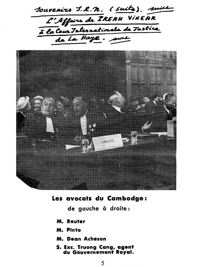
The court proceedings focused not on questions of cultural heritage or on which state was the successor to the Khmer Empire, but rather on Siam’s supposed long-time acceptance of the 1907 map. Arguing in The Hague for Cambodia was former U.S. Secretary of State Dean Acheson, while Thailand’s legal team included a former British attorney general, Sir Frank Soskice. Cambodia contended the map showing the temple as being on Cambodian soil was the authoritative document.
Thailand argued that the map was invalid and that it was not an official document of the border commission, and that it clearly violated the commission’s working principle that the border would follow the watershed line, which would place most of the temple in Thailand. If Thailand had not protested the map earlier, the Thai side said, it was because Thai authorities had had actual possession of the temple for some period of time, due to the great difficulty of scaling the steep hillside from the Cambodian side, or simply had not understood that the map was wrong.Illustration of temple structures
On 15 June 1962, the court ruled 9 to 3 that the temple belonged to Cambodia and, by a vote of 7 to 5, that Thailand must return any antiquities such as sculptures that it had removed from the temple. In its decision, the court noted that in over the five decades after the map was drawn, the Siamese/Thai authorities had not objected in various international forums to its depiction of the temple’s location. Nor did they object when a French colonial official received the Siamese scholar and government figure Prince Damrong at the temple in 1930 (possibly before the Thais realised the map was wrong). Thailand had accepted and benefited from other parts of the border treaty, the court ruled. With these and other acts, it said, Thailand had accepted the map and therefore Cambodia was the owner of the temple.
“It was clear from the record, however, that the maps were communicated to the Siamese Government as purporting to represent the outcome of the work of delimitation; since there was no reaction on the part of the Siamese authorities, either then or for many years, they must be held to have acquiesced. The maps were moreover communicated to the Siamese members of the Mixed Commission, who said nothing, to the Siamese Minister of the Interior, Prince Damrong, who thanked the French Minister in Bangkok for them, and to the Siamese provincial governors, some of whom knew of Preah Vihear. If the Siamese authorities accepted the Annex I map without investigation, they could not now plead any error vitiating the reality of their consent.
The Siamese Government and later the Thai Government had raised no query about the Annex I map prior to its negotiations with Cambodia in Bangkok in 1958. But in 1934-1935 a survey had established a divergence between the map line and the true line of the watershed, and other maps had been produced showing the Temple as being in Thailand. Thailand had nevertheless continued to also use and indeed to publish maps showing Preah Vihear as lying in Cambodia. Moreover, in the course of the negotiations for the 1925 and 1937 Franco-Siamese Treaties, which confirmed the existing frontiers, and in 1947 in Washington before the Franco-Siamese Conciliation Commission, Thailand was silent. The natural inference was that Thailand had accepted the frontier at Preah Vihear as it was drawn on the map, irrespective of its correspondence with the watershed line.[7] “
Australian judge Sir Percy Spender wrote a scathing dissent for the minority on the court, however, pointing out that the French government had never mentioned Thai “acquiescence” or acceptance at any time, not even when Thailand stationed military observers at the temple in 1949. On the contrary, France always insisted that their map was correct and the temple was located on their side of the natural watershed (which it clearly is not). Thailand had modified its own maps, which in Spender’s opinion was sufficient without having to protest to France. Spender said:
Whether the Mixed Commission did or did not delimit the Dangrek, the truth, in my opinion, is that the frontier line on that mountain range is today the line of the watershed. The Court however has upheld a frontier line which is not the line of the watershed, one which in the critical area of the Temple is an entirely different one. This finds its justification in the application of the concepts of recognition or acquiescence.
With profound respect for the Court, I am obliged to say that in my judgment, as a result of a misapplication of these concepts and an inadmissible extension of them, territory, the sovereignty in which, both by treaty and by the decision of the body appointed under treaty to determine the frontier line, is Thailand’s, now becomes vested in Cambodia.
Thailand reacted angrily. It announced it would boycott meetings of the Southeast Asia Treaty Organization, with Thai officials saying this step was to protest a U.S. bias toward Cambodia in the dispute. As evidence, Thai officials cited Acheson’s role as Cambodia’s advocate; the U.S. government replied that Acheson was merely acting as a private attorney, engaged by Cambodia. Mass demonstrations were staged in Thailand protesting the ruling. Thailand eventually backed down and agreed to turn the site over to Cambodia. Rather than lower the Thai national flag that had been flying at the temple, Thai soldiers dug up and removed the pole with it still flying. The pole was erected at nearby Mor I Daeng cliff, where it is still in use.
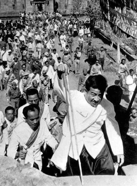
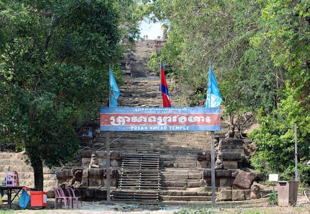
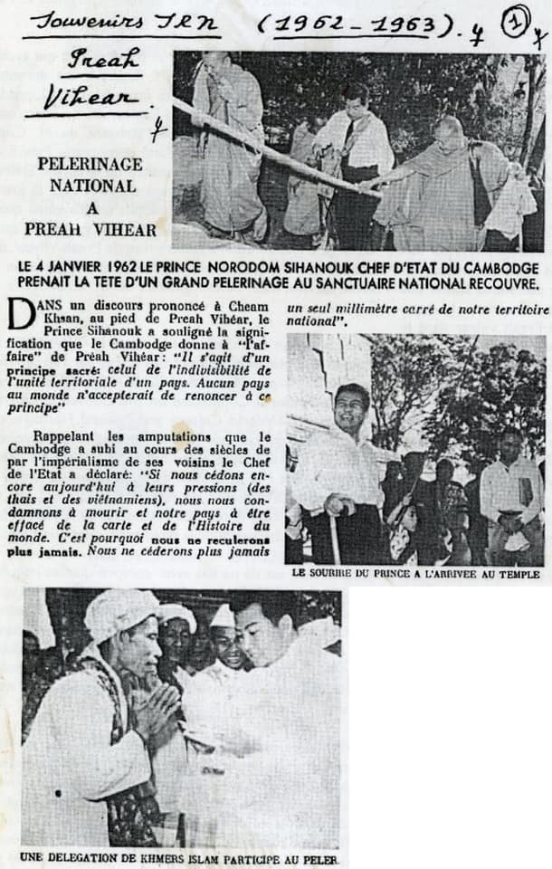
In January 1963, Cambodia formally took possession of the site in a ceremony attended by around 1,000 people, many of whom had made the arduous climb up the cliff from the Cambodian side. Prince Sihanouk, Cambodia’s leader, walked up the cliff in less than an hour, then made offerings to Buddhist monks. He made a gesture of conciliation in the ceremony, announcing that all Thais would be able to visit the temple without visas, and that Thailand was free to keep any antiquities it may have taken away from the site. Wikipedia and AREY